
search
Brussels metro map
Bruxelles metro map. Brussels metro map (Belgium) to print. Brussels metro map (Belgium) to download. The Brussels Metro (French: Métro de Bruxelles, Dutch: Brusselse metro) is a rapid transit system serving a large part of the Brussels-Capital Region of Belgium as its shown in Brussels metro map. Brussels metro consists of a network with four metro line services with some shared sections. The Brussels metro has 49.9 km of network and 59 stations. The premetro network in Brussels consists of two underground sections used by otherwise open-air Brussels tram lines and designed so as to be convertible to conventional metro lines.
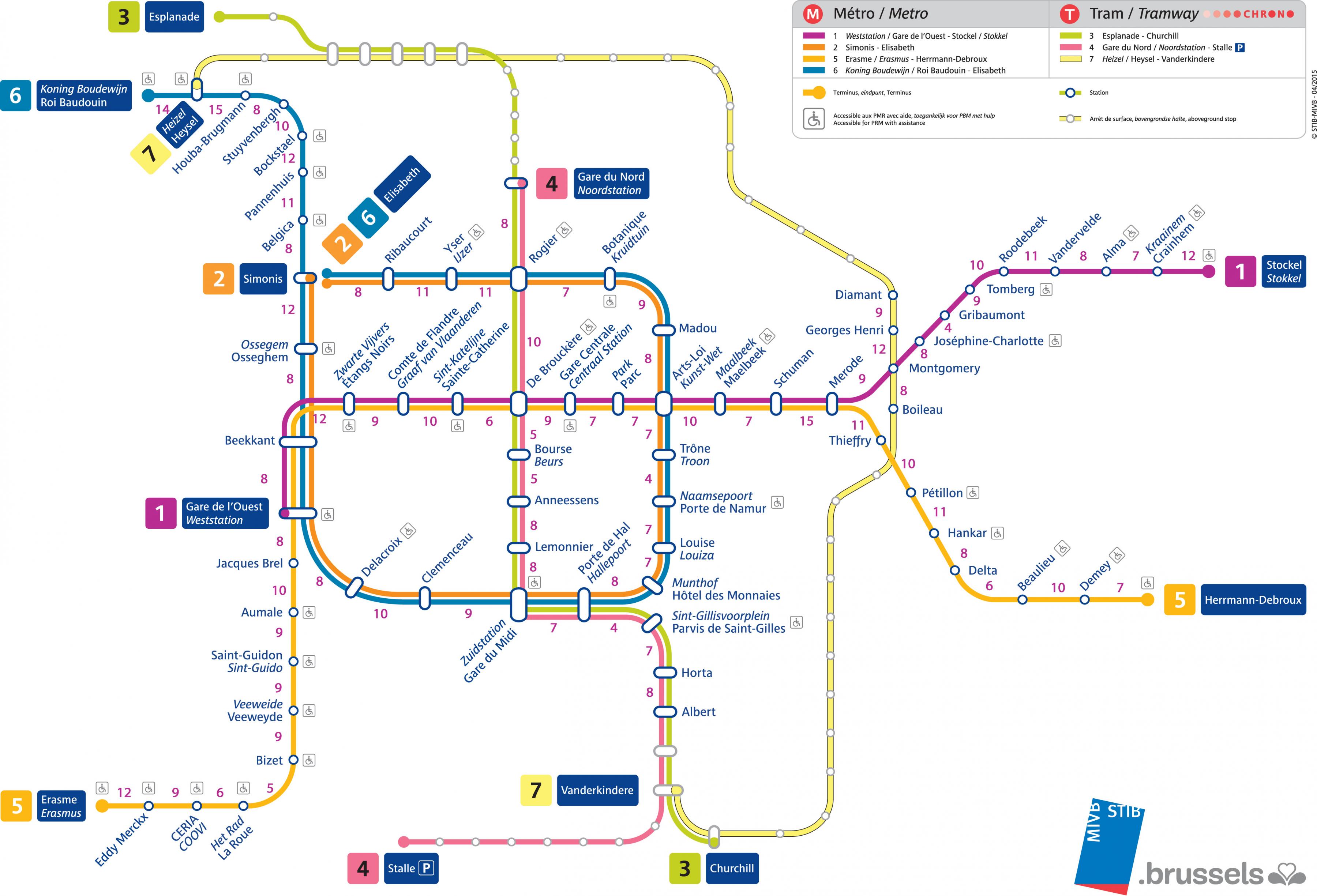
The Brussels metro is administered by STIB/MIVB (French: Société des Transports Intercommunaux de Bruxelles, Dutch: Maatschappij voor het Intercommunaal Vervoer te Brussel). In 2008 the Brussels metro has been used for a total of 135.5 million journeys. The Brussels metro is an important means of transportation in Brussels, which connects with 6 railway stations of the National Railway Company of Belgium, as well as with many Brussels tram and bus stops operated by STIB/MIVB and with Flemish De Lijn and Walloon TEC bus stops (see Brussels metro map).
The STIB/MIVB was created in 1954. The first underground tramway (or premetro) line was built between 1965 and 1969; it ran from Schuman to De Brouckère. In 1970 a second line was opened, between Madou and Porte de Namur/Naamsepoort as its mentioned in Brussels metro map. An underground station of Brussels metro at Diamant was opened in 1972 and the "outer ring" line was extended from Diamant to Boileau in 1975.
The metro system has 4 conventional metro lines as you can see in Brussels metro map. There are, as of 2008, 59 stations on the metro network (not including premetro). Most of those stations of Brussels metro are underground though some of them on lines 5 and 6 are located at ground level. On 4 April 2009, the connection at Gare de l'Ouest/Weststation that enables line 2 to form a circular line was put into service. As a consequence, the metro network of Brussels was significantly reorganised. The development plan for this change and related tram and bus network changes was approved by the Brussels Capital Region in July 2005.